

Moon rising over Delicate Arch, photo by Jackson Mann
“A weird, lovely, fantastic object out of nature like Delicate Arch has the curious ability to remind us – like rock and sunlight and wind and wilderness – that out there is a different world, older and greater and deeper by far than ours, a world which surrounds and sustains the little world of men as sea and sky surround and sustain a ship. The shock of the real. For a little while we are again able to see, as the child sees, a world of marvels. For a few moments we discover that nothing can be taken for granted, for if this ring of stone is marvelous then all which shaped it is marvelous, and our journey here on earth, able to see and touch and hear in the midst of tangible and mysterious things-in-themselves, is the most strange and daring of all adventures.”
Edward Abbey, Desert Solitaire
, Chapter: Cliffrose and Bayonets, p. 37.)
 The Colorado Plateau of northern Arizona and southern Utah is one of the most striking regions of North America. It combines one of the lowest numbers of human inhabitants per square mile with one of the highest numbers of national parks and monuments, including the Grand Canyon, Zion, Bryce, and Arches. I remember the slides taken of our family visiting these strange, exotic places when I was a child, beyond the reach of actual memory yet always present to my imagination.
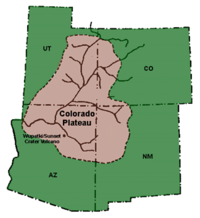
Thanks to Mother and Dad, we enjoyed a large family gathering in the Phoenix area, following which about 13 of us made a pell-mell dash around the Colorado Plateau. Thanks to Laura and Jackson for the photos which illustrate this post. Thanks to Stephen for putting together the ambitious itinerary that made it possible for us to see so many facets of this strange and varied land in a short span of time. Like a Bach fugue, the Colorado Plateau is a giant theme with many variations: a vast uplifted desert, with layer-cake formations exposed like a grand staircase and cut through by canyon-forming rivers. (In the section below, observe Bryce Canyon in the upper right, Zion in the middle, and the Grand Canyon on the lower left. See: Anne Egger; Ron Blakey; USGS.)

From the beginning, we told ourselves we were only scouting out the land. Rather than staying in one or a few places long enough to immerse ourselves in its character and history, we elected to make a reconnaissance trip of the entire plateau, so that next time we might better appreciate any particular place on its own. As Rick Steves says, “Expect to return.”
In anticipation of a return, and for the sake of friends who may ask us about a Grand Tour, I will outline below a circle path one might follow to gain a holistic sense of the Colorado Plateau. Several weeks would be needed; on our brief trip, we did not visit every site and in no place did we linger long enough. My Grand Tour begins in NE Arizona on the way to Phoenix, but one could begin the circular itinerary at any point.
There are many ways to experience new country. To travel with a fisherman, one experiences new country primarily alongside its rivers and lakes. Traveling with a hiker or cyclist involves seeking out the bicycle trails and footpaths. Compared with hiking or cycling, the view from the back of a horse has its own distinctive rhythm, adding the responsibility of caring for a living and breathing fellow traveling companion. If the friend is not a horse but a pilot, one views the country from overhead, with a wide angle. To travel with a reader or movie-goer requires quiet, unhurried time to experience literary and cinematic works in situ. These ways and others are fun and enlightening, so kerrymagruder.com out opportunities for a wide variety of perspectives.
Yet even from the roadside or on short and easy hikes, one imaginative way to approach unfamiliar places is from the perspective of geology and history. Where they intersect, the human and natural stories interweave in an endlessly varied tapestry. These are some guides I recommend for becoming acquainted with the natural and human stories of the Colorado Plateau:

![]()
Grand Tour of the Colorado Plateau
1. Petrified Forest, Painted Desert National Parks, AZ. An audio tour is available in the Visitor Center gift shops.
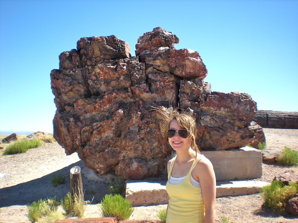
Rachel at Petrified Forest
2. Mogollon Rim – the south boundary of the Colorado Plateau. From the Petrified Forest go south, following State Highways 377 to Heber, 270 to Payson, and 87 to Phoenix. One could actually fall off the Colorado Plateau over the steep Mogollon Rim. Keep those roadside guides handy. We gathered at A.T. Still University in Mesa (cf. Laura’s post).
3. Grand Canyon National Park, AZ (USGS). We visited the North Rim this time, which was definitely worth the extra driving time. The drive north of Flagstaff on US-89 through Navajo land along the Echo cliffs takes one through the northwestern tip of the painted desert. This drive is a singularly striking introduction to the desert country and superbly exemplifies the Colorado Plateau. When you turn westward along the Vermillion Cliffs south of Page toward the North Rim, the view of the Kaibab Plateau is striking. The Kaibab Plateau is an island of alpine forest rising above the surrounding desert which laps at its shores, while the Grand Canyon cuts the south side. We stayed at Jacob’s Lake Inn, which is excellent, although next time we’ll try for a National Park cabin right on the North Rim.
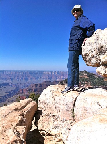
Candace on the North Rim
Candace and I laughed our way through a hilarious account of a mule-ride into the Grand Canyon by Donald Davis. Listen to The Grand Canyon – Donald Davis. It’s a hoot.
4. Page, AZ (at least a full day): Horseshoe Bend, Antelope Canyon, Glen Canyon Dam and Lake Powell (USGS). One of the high points of the trip for me was the moment a Navajo guide walked through Antelope Canyon playing his Navajo flute. Surrounded by windswept ancient sand-dunes fossilized into this stunning slot canyon, it just seemed appropriate to pause to listen to the wind of his breath passing through the desert flute. One of my favorite souvenirs of the trip is the CD Radiant Sky by Scott August, which features a Navajo flute.
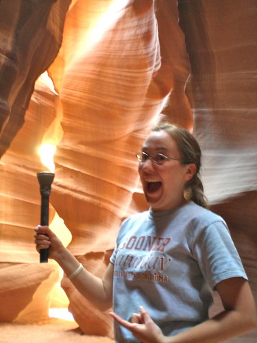
Hannah at Antelope Canyon
5. Zion National Park, UT (USGS). The drive from Page, AZ to Springdale, UT, is again spectacular. Keep those roadside guides handy. We stayed at the Bumbleberry Inn in Springdale. The Wayside Tours and Patricia Lawrence audio guides to Zion were helpful (we listened to them on the way), as was riding the shuttle from the Visitor’s Center to the end of the line to get our bearings. Laura and Marvin and family, who stayed at Zion Lodge, got to do this on a late Moonlight Ride, an ideal way to let Zion introduce itself.
Zion Canyon is distinguished by its near vertical walls which create a massive grandeur. Truly awesome. Although Zion is in desert country, due to the Virgin River and the seeping rocks and springs, inside the canyon the vegetation can be surprisingly lush. Rachel commented that the descent into Zion as we arrived reminded her of Rivendell.
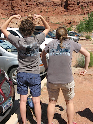
Warm up the first day with brief walks to the Emerald Pools, Weeping Rock (my favorite), and the lush riverside walk from Sinawava Temple, where we watched a California Condor soar overhead – an unforgettable sight. If more ambitious, on later days hike the Canyon Overlook Trail, wade through the Narrows, and climb Angel’s Landing. Plan ahead for these: come prepared with proper footwear, water bottle, hat, sunscreen, sunglasses, energy snacks and other gear. Next time we’re going to try out walking poles to keep us from turning an ankle on the softball-sized rounded rocks that cover the bed of the Virgin River, and we’ll come with hiking boots that offer strong ankle support and good traction on wet surfaces. And we won’t forget the binoculars.
We could spend a week in Zion without batting an eye.
Before leaving, don’t miss the unusually beautiful Kolob Canyons area in northwest Zion. The Kolob Canyon area also affords a dramatic view of the western edge of the Colorado Plateau.
Kolob Canyons are on the way to the spectacular State Highway 14, which runs along the north side of Zion through Dixie National Forest and affords a glimpse of Zion Canyon from above. The extensive lava flows are a remarkable sight, distributed among aspen and pine forests, with plenty of snowfall remaining on the ground. What a total about-face from the heat of the desert below. Laura particularly enjoyed the signs saying “8% grade” or “No stopping or standing next 2 miles due to falling rocks” as well as the ones that had so many s-shaped squiggles they would tie a snake in knots. In one place the lane turned to gravel where a landslide must have knocked it out this past winter. But the view was well worth it! Next time we’ll also check out Cedar Breaks National Monument. Plan on a full day to travel from Springdale through Kolob Canyon and Hwy 14 to Bryce.
(Laura’s post on Zion, Kolob, and Hwy 14.)
6. Bryce Canyon National Park, UT. Among canyons in the desert southwest, Bryce stands out for its varied colors and delicate structures. The Grand Canyon might as well be infinite for the way its immensity plays tricks upon sensory perception. Zion’s massive verticality is an awesome Romanesque cathedral. Bryce, in comparison, appears less imposing, more comprehensible. We caught Sunset Point at sunset. Beautiful.

Bryce Canyon, from Sunset Point, by Jackson Mann
On the way out, we gave a lift to Michelle and Marie-Claire, from Orléans, France, who had missed the last shuttle back to their hotel. Although National Parks inevitably are crowded tourist destinations (campgrounds and hotels require advance reservations), one of the compensating joys is the number of languages one hears spoken in them. We were thrilled to meet this wonderful French couple and have the chance to talk with them for a while. Likewise in Zion, within a blind arch carved away behind a waterfall, we were treated to the echo-producing yodels of a Swiss man who was traveling with Hebrew-speaking companions from Israel. What a small world, indeed.
Trails below the rim open up another world. An early settler remarked that Bryce is “a hell of a place to lose a cow.” Be careful and save your strength when hiking: after seeing what you go afoot to see, the only way home is up.
Recommendation for next time: spend several nights at Bryce. (Cf. Laura’s post.)
7. Take your time traveling from Bryce to Arches along State Highways 12 and 24, which eventually join up with I-70, west of Green River. Like Highway 14 north of Zion, this is one of the most scenic highway stretches in the American southwest, where desert features alternate with alpine meadows and aspen forests. Hwy 24 runs through Capitol Reef National Park. My friend Ken advises:
“As you approach Boulder, there is an incredible section where the road goes along the top of a ‘backbone’. Pull off the road somewhere on this section for fantastic Grand Staircase
At Boulder, by the way, the Hell’s Backbone Grill
Capitol Reef
To continue on from Cap Reef toward Arches, you go east from Capitol Reef to Hanksville. Here you have a choice of the shorter, dull way to Arches (north on 24 to I-70) or the somewhat longer, very scenic way, south and SE on 95 to the crossing at the upper end of Lake Powell. This has the advantage, too – if you have time to do it – of a possible look at Natural Bridges
Keep that roadside geology guide handy, even on I-70 where the roadcuts and panoramas are astonishing. At Green River, stop at the John Wesley Powell River History Museum, where after we had gone on down the road following a picnic lunch, a kind worker fished my daughter’s retainer out of the trash and saved it for us. There must be a special circle of heavenly joy awaiting those who assist hapless travelers on their way.
8. Arches National Park, UT. The Visitors Center sells an audio tour with an accompanying paperback booklet. As in all parks, ranger tours are informative. We hiked the trail to Delicate Arch at sunset, then stayed put as a one-day from Full Moon rose above the arch. Sublime. I wanted to stay in Arches long enough to read Desert Solitaire. And find the double arch that appears in the prologue of Indiana Jones and the Last Crusade. (Cf. Laura’s post.)
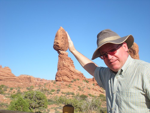
A giant vandal tries to push over the Balancing Rock (which is 6 stories high)
9. Canyonlands National Park, UT (USGS). An audio tour and booklet is available in the Arches Visitor Center. Again, Ken writes:
“Mesa Arch (a short walk, perhaps 20 minutes round trip from the road). Green River Overlook (this is the one I would choose if allowed only one stop). Grandview point overlook. Dead Horse Point
As you head south, admire the La Sal mountains to the east.
10. Either on the way south from Canyonlands, or after visiting Monument Valley, take a detour east to spend a day or two near Cortez, Colorado, at Mesa Verde National Park (USGS), near the boundary between the Colorado Plateau and the mountain chains that make up the backbone of the state. Cliff House – the largest settlement – is a guided tour. Spruce House is self-guided, and to us, the most interesting. Next time we’ll try Balcony House, a guided tour which involves more climbing. (Cf. Laura’s post.)
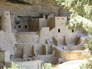
Mesa Verde, photo by Jackson Mann
11. Monument Valley, UT. During the Great Depression, the impoverished Navajo funded Harry Goulding’s trip to Hollywood where he persuaded John Ford to shoot films on Navajo land. The result was a string of westerns starring John Wayne. Check out Where God Put the West by Bette L. Stanton. The main overlook is a Navajo Nation Park. As we drove away, Susanna paused the movie she was watching – Spirit, Stallion of the Cimarron – to show us a frame that exactly matched this view from the main overlook:
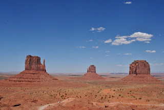
Monument Valley, photo by Jackson Mann
(Cf. Laura’s post.)
Several amazing sites, as Ken notes, are easily reachable from a base hotel at Bluff, Mexican Hat, or Monument Valley:
“As you approach Mexican Hat (NE of Monument Valley) from the north, there are at least two very enticing prospects of side trips: the Valley of the Gods
12. Canyon de Chelly National Monument, AZ (USGS). From here, it’s a quick trip down US-191 to I-70 to complete the grand circle tour.
See our photo gallery. Now I’m ready to read some Louis L’Amours and watch some old westerns.
Expect to return!
Wonderful, wonderful, wonderful!! Thank you for this post and all the fantastic resources!! I intend to share this one!! 🙂 What a fantastic trip it was and I cannot wait to return!! 🙂
Thanks, Laura, for YOUR posts on the trip! And for the photos! (Give Jackson my compliments; I want to see them all.) Thanks especially for traveling with us – seeing all these sights with your family made it much more fun. BTW, what was the book Marvin has on the movies of Arches and Monument Valley? I’d like to insert a link to that in the post.
PEACE, Kerry
Pingback: 25 years! | Kerry's loft
Pingback: 25 years! | Kerry's loft
Pingback: Merry Christmas 2011 | Kerry's loft